UPDATE: THE ROUTE TO THE FALLS AND PARKING HAVE CHANGED. PLEASE READ THE COMMENTS
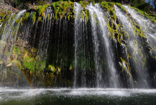
Mossbrae Falls is a small but verdant waterfall on the Sacramento River just a few miles South of Mount Shasta. In the spring the green of the moss and aquatic plants is overwhelming.
The waterfall is reached after about a 1 mile hike along the Sacramento River. The trail is along the railroad right-of-way so be careful to step to the side when you hear a train coming. For this reason, it is not recommended for children younger than about 6.
The picture above was taken in the late afternoon in mid-April. The waterfall is on the East side of the river, so sun and rainbows are going to be at their best in the afternoon.
Getting There: The starting point for this hike is in Dunsmuir California. Turn West on Scarlett Way from Dunsmuir Avenue. It is a sharp turn if you are heading South, so be careful not to miss it. Continue on Scarlett until you cross the river and park in one of the dirt lots. This is the starting point for the hike.
The Hike: Continue North (upriver) along the tracks about 1 mile. Along the way you will see columns of basalt which should remind you of the area's igneous origins. We also found some chunks of lava flow which came from higher up the cliff walls. At some points along the tracks, the path narrows or crosses the tracks. Be careful to leave room to step aside when you are hiking. The trains pass through fairly often so you will likely see at least one. They are loud though, so don't worry about them sneaking up on you.
After about a mile you will reach an area where the trail widens and there is a railroad trestle with the year 1901 marked on it. At this point look for the trail down to the river through the small stand of trees. It will lead to to a rocky beach just across the river from the falls. There are a number of places to sit and watch the falls or eat a snack, but please bring a bag to pack all your waste out. There are NO trash or bathroom facilities here.
Recommendation: This trip was the highlight of the day for my grammar school age children. I give it 4 stars for beauty, geology, the clear water and the trains.
Zoom in on the map to see the route. The green marker is the start of the hike. The blue marks the waterfall.
View Mossbrae Falls, Dunsmuir California in a larger map

Comments (3)
The trail to the falls was closed on August 10, 2010. A new trail will be opening at the Hedge Creek Falls. This way people will be able to access both falls. To verify this information you can go to the Dunsmuir Chamber of Commerce page http://www.dunsmuir.com/visitor/outdoor.php
Posted by Wendi | July 3, 2011 3:07 PM
Posted on July 3, 2011 15:07
There is no longer parking available to start the walk up the tracks. The railroad has closed the parking lot and there is no other parking. Over the 4th of July over 400 parking tickets were given out. Also, the railroad has had people giving out tickets for trespassing. Please put this warning on you page. I hate to see people trying to enjoy this beautiful place get tickets!
Thank you
Posted by Barbara | July 16, 2011 11:50 PM
Posted on July 16, 2011 23:50
Please note: Any cars parked on private property or on any part of the pavement are subject to citation by local law enforcement and/or Union Pacific Railroad police. Please don't encroach on any residence/rental properties or park in the road.
Posted by Kevin harris | July 31, 2011 6:22 PM
Posted on July 31, 2011 18:22